Cape Cod’s Aquifer: What to Know About Our Water Supply
Ongoing drought declarations and questions from local officials have brought new attention to Cape Cod’s water supply. In recent months, Cape Cod Commission staff have shared updates on water conditions and long-term planning efforts recommended in the 2025 Regional Policy Plan (RPP). One of the RPP’s key goals is to maintain a reliable supply of clean drinking water while protecting the Cape’s ponds, streams, and coastal waters.
Although we often talk about the aquifer as one system, Cape Cod’s groundwater is made up of six separate "lenses," which are distinct mounds of underground water separated by natural barriers. While they function similarly, they don’t naturally connect. Water moves between them only when we pump and pipe it for drinking water.
All of our groundwater comes from precipitation. On average, the Cape receives enough precipitation to recharge about 450 million gallons a day. Most of that slowly flows toward the coast, while roughly 7 percent is withdrawn through more than 160 public water supply wells. The rest supports wetlands, streams, and coastal habitats.
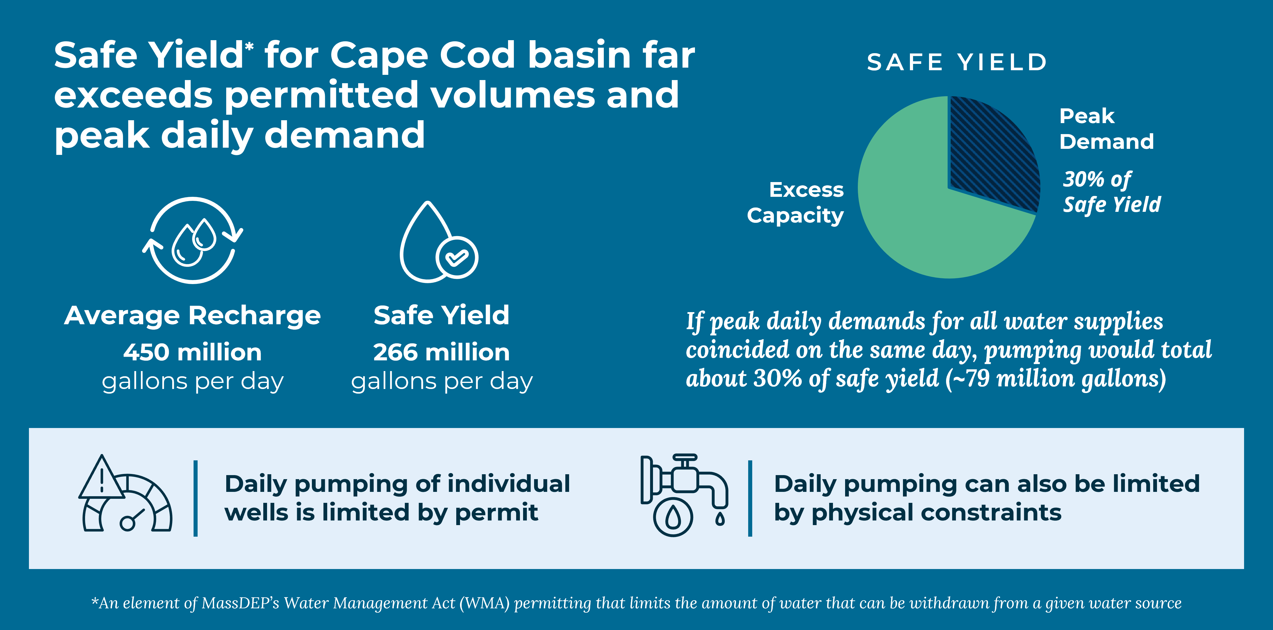
Today, the region’s water use is about 11 billion gallons a year, which provides a buffer for some additional demand to be met within permitted capacity. This is well below permitted limits. Even if every supplier hit its highest recorded demand on the same day, Cape Cod would still use only about 30 percent of the aquifer’s “safe yield.” This is the maximum amount considered sustainable by the Massachusetts Department of Environmental Protection (MassDEP) to protect ecosystems during drought.
As Water Resources Analyst Tim Pasakarnis explains, “Water supply is well in excess of our current demand. The challenge is being able to pump it when and where we need it.”
Demand rises sharply in the summer. Nearly half of the region’s annual water use happens between July and September, and some systems see usage triple compared to winter. For example, a typical town might see daily water use jump from 1 million gallons per day in January to over 3 million per day in July. Pumping, treatment, and distribution systems all must be sized to meet this peak demand, despite much of that capacity going unused the rest of the year.
This seasonal surge puts pressure on individual wells. Some can’t physically pump more water, while others are limited during drought to protect sensitive ponds and streams. Maintaining a buffer is essential. Running wells at full tilt leaves no margin for emergencies, equipment failures, or sudden drops in groundwater levels.
Balancing customer needs with ecological protection and system resilience is a constant challenge.
While building new wells is part of Cape Cod’s long-term strategy, it’s neither quick nor easy. Developing a new well typically takes 7 to 10 years and requires about 11 acres of protected land. Recent mapping shows that only about 10 percent of the Cape is suitable for future well sites.
Cape Cod has faced repeated drought declarations for more than two years. Seasonal dryness is becoming more common, straining both natural resources and water systems. Climate change is projected to increase the frequency and severity of droughts, making water conservation and careful planning even more important.
The 2025 Regional Policy Plan calls for new tools, including a dynamic groundwater model developed with the U.S. Geological Survey, to help better predict how water levels respond seasonally to drought, pumping, and wastewater disposal. The Commission is also expanding aquifer‑protection planning to support towns with updated data and strategies.
Cape Cod’s water supply remains strong, but the region’s unique environment and changing climate mean that resilience depends on smart planning and responsible water use. Residents, businesses, and local governments all play a role in safeguarding this vital resource for the future.
Related Posts