- Project: New England Wind 1 Connector (f/k/a Vineyard Wind II) (CCC File No: 22005)
- Project Applicants: Park City Wind, LLC
- Project Location: Town of Barnstable
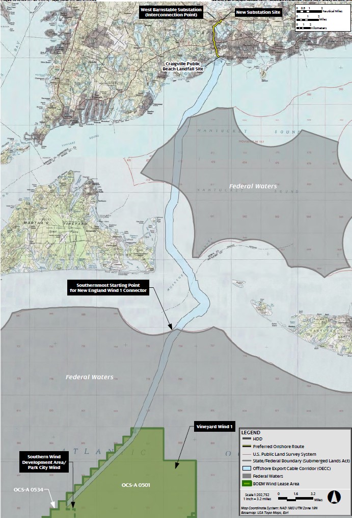
- Project Description: Construction and operation of the portion of the New England Wind 1 connector located within Barnstable County, which Project is intended to connect to and serve the proposed approximately 800-megawatt New England Wind 1 offshore wind project. The Project includes, without limitation, offshore export cables located within Barnstable County waters; the cable landfall site at Craigville Beach; the onshore duct bank and associated onshore export cables located within and under existing rights of way through the village of Centerville; the proposed onshore substation located at 8 Shootflying Hill Road; and interconnection to the electric grid at the existing West Barnstable Substation on Oak Street.
New England Wind 1 Cable Route Map
Individual Public Comment Files, titled by date received
April & May 2023 Combined Comments, Bookmarked PDF, organized by date received
February & March 2023 Combined Comments, Bookmarked PDF, organized by date received
Project Resources
188M pdf
Jun 25, 2022
2022-06-10 New England Wind 1 DRI App
…2022-06-10 New England Wind 1 DRI App.pdf dept/commission/team/member/Project…
105K pdf
Mar 31, 2023
New England Wind 1 Comments-How to View
To view public comments submitted on the New England Wind Connector, CCC No. 22005 …New England Wind 1 Comments-How to View.pdf dept/commission/team/member/Project Documents/…Wind …
427K pdf
May 05, 2023
2023-05-01 NE Wind 1 FINAL DRAFT Decision
…2023-05-01 NE Wind 1 FINAL DRAFT Decision Microsoft Word - 2023-05-01 NE Wind 1 FINAL … Decision New England Wind 1 Connector, CCC No. 22005 DRI Decision | May 2023 1 of 29 CAPE…
