Overview
Engineers and other technical staff must estimate high groundwater levels to maintain proper separation from groundwater when designing on-site septic systems under Title 5 (310 CMR 15.000 The State Environmental Code), stormwater management systems, and for other purposes. The Cape Cod Commission's Technical Bulletin 92-001, "Estimation of High Groundwater Levels for Construction and Land Use Planning" (revised in 2006), provides a method to use current water level measurements at the project site in conjunction with monthly index well data to estimate the maximum seasonal high groundwater level.
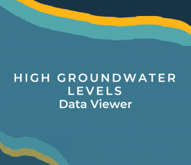
The High Groundwater Levels Data Viewer is the most up-to-date and accessible data resource for users to determine high water levels across the Cape. The Viewer incorporates measurements for all current index wells and corresponding adjustments from the updated adjustment tables. Groundwater levels for index wells are measured monthly, and are accessible in the Monthly Groundwater Levels resource. The groundwater adjustments found in the Viewer and Monthly Groundwater Levels resource should be used with all depth to groundwater measurements from January 2022 and on. Use the High Groundwater Levels Data Viewer and follow the steps in the info panel to determine the adjusted seasonal high groundwater level. Steps to determine seasonal high groundwater level are also listed below, and within the Computation Form.
How to Determine Groundwater Levels:
Step 1. Measure the depth-to-water at the project site.
Step 2. Identify the representative index observation well and annual groundwater-level-range zone for the project site. Using the High Groundwater Levels Data Viewer, find and click on the parcel location or type an address into the search bar located in the upper right corner of map. A dialog box pops up indicating the index observation well and the zone.
Step 3. Determine the current depth-to-water level for the index well. The most recent measurement for the applicable index well is displayed in the High Groundwater Levels Viewer dialogue box for the selected location or address. Previous index well measurements are available in the Monthly Groundwater Levels resource. Measurements taken prior to January 2022 are available in Additional Resources under (or click on) Past Well Data and Reports linked below.
Step 4. Determine water-level adjustment. This adjustment number is also provided in the High Groundwater Levels Viewer dialogue box.
Step 5. Estimate high water level at your project site by subtracting the water level adjustment (Step 4) from the measured depth-to-water at the project site (Step 1).
Resources
Click the images below to access the resources.
Contact
-
Tim Pasakarnistim.pasakarnis@capecodcommission.org
-
Tara Nye Lewistara.lewis@capecodcommission.org